Hurricane Harvey Local Statement: Houston-Galveston
Source: Getty Images
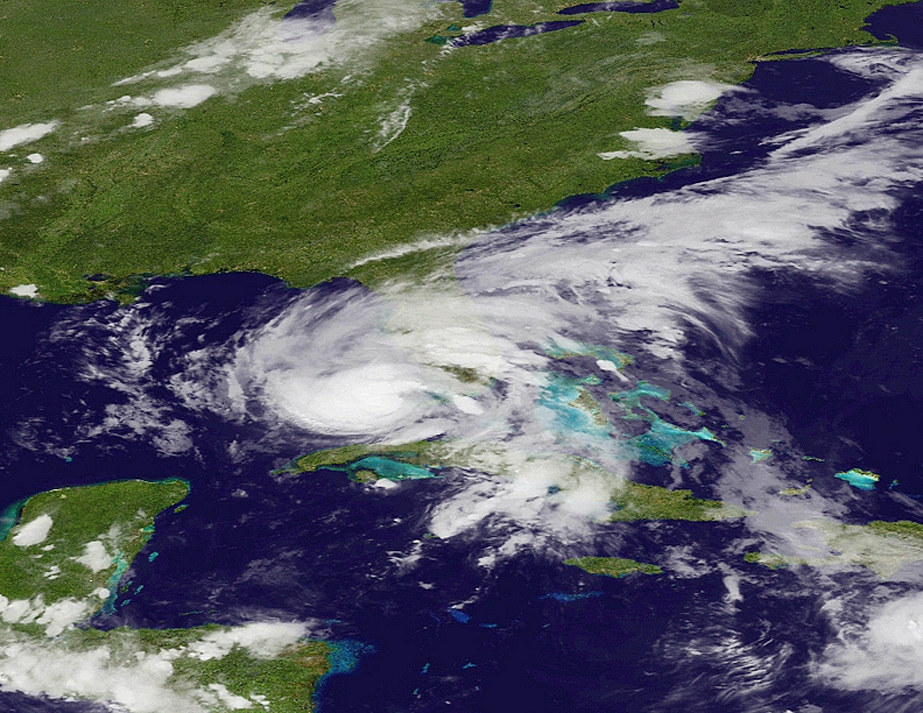
This product covers SOUTH TEXAS **HURRICANE HARVEY DANGEROUSLY APPROACHING THE TEXAS COAST** NEW INFORMATION ————— * CHANGES TO WATCHES AND WARNINGS: – None * CURRENT WATCHES AND WARNINGS: – A Storm Surge Warning and Hurricane Warning are in effect for Aransas, Calhoun, Kleberg, Nueces, Refugio, San Patricio, and Victoria – A Tropical Storm Warning is in effect for Duval and McMullen – A Hurricane Warning is in effect for Bee, Goliad, Jim Wells, and Live Oak * STORM INFORMATION: – About 185 miles south-southeast of Port Oconnor TX or about 180 miles southeast of Corpus Christi TX – 25.9N 95.4W – Storm Intensity 105 mph – Movement Northwest or 320 degrees at 9 mph
SITUATION OVERVIEW —————— Hurricane Harvey is expected to continue to strengthen as it moves toward the Texas Coast through Friday. Harvey is a Category 2 hurricane, with sustained winds of 105 mph. Harvey is expected to reach Category 3 status prior to landfall. Tropical storm force winds are expected to reach coastal areas of the Coastal Bend as early as later this morning. Hurricane force winds will be possible as early as this afternoon. Heavy rainfall is expected through much of the area with rainfall totals of 20 to 30 inches near, north and east of a line from near Port Aransas to near Goliad. Outside that area, amounts of 10 to 20 inches are expected from near and east of a Loyola Beach to near George West line. Lesser amounts are expected further west and southwest. These numbers and locations are subject to change depending on the exact location of landfall along the Texas coast, as well as how long Harvey meanders over South Texas. These high rainfall amounts will likely produce devastating and life threatening flash flooding. The heaviest rains are expected to occur from late Friday afternoon through Saturday night, and quite possibly into early next week depending on how long Harvey remains over the area. Peak Storm surge inundation is generally expected to be 6 to 12 feet above ground level from near Mustang Island to Port O`Connor. South of Mustang Island storm surge is generally expected to be 4 to 6 feet above ground level. Impacts would be felt along the Barrier Islands and into the inland bays and waterways. Isolated locations could see slightly higher inundation. Tornadoes and waterspouts are possible as rainbands move onshore early this morning through Saturday, especially north and east of the center of Harvey. Mandatory evacuations have been issued for the following areas: – The city of Port Aransas – Aransas County – Refugio County – San Patricio County – Victoria County – Calhoun County – Eastern Kleberg County (Baffin Bay, Loyola Beach and Rivera Beach and areas east) CHRISTUS Spohn Health System to close certain locations: – CLOSED: Robstown, Northside, Westside, Padre Island, Freer, Beeville, Dr. Hector P. Garcia, and Memorial Quick Care (Reopen Monday, August 28). – CLOSED: CHRISTUS Physician Group physician practices. – ABBREVIATED WORK SCHEDULE: Promptu Clinics will operate a shortened schedule on Friday, August 25.
POTENTIAL IMPACTS —————– * SURGE: Prepare for life-threatening surge having possible devastating impacts across the Middle Texas Coast and Barrier Islands. Potential impacts in this area include: – Widespread deep inundation, with storm surge flooding greatly accentuated by powerful battering waves. Structural damage to buildings, with many washing away. Damage greatly compounded from considerable floating debris. Locations may be uninhabitable for an extended period. – Near-shore escape routes and secondary roads washed out or severely flooded. Flood control systems and barriers may become stressed. – Extreme beach erosion. New shoreline cuts possible. – Massive damage to marinas, docks, boardwalks, and piers. Numerous small craft broken away from moorings with many lifted onshore and stranded. * WIND: Prepare for life-threatening wind having possible devastating impacts across essentially all of the Coastal Bend and Victoria Crossroads area. Potential impacts in this area include: – Structural damage to sturdy buildings, some with complete roof and wall failures. Complete destruction of mobile homes. Damage greatly accentuated by large airborne projectiles. Locations may be uninhabitable for weeks or months. – Numerous large trees snapped or uprooted along with fences and roadway signs blown over. – Many roads impassable from large debris, and more within urban or heavily wooded places. Many bridges, causeways, and access routes impassable. – Widespread power and communications outages. Also, prepare for life-threatening wind having possible significant to extensive impacts across McMullen and Duval Counties. * FLOODING RAIN: Prepare for life-threatening rainfall flooding having possible devastating impacts across he Coastal Bend and Victoria Crossroads area. Potential impacts include: – Extreme rainfall flooding may prompt numerous evacuations and rescues. – Rivers and tributaries may overwhelmingly overflow their banks in many places with deep moving water. Small streams, creeks, canals, and ditches may become raging rivers. Flood control systems and barriers may become stressed. – Flood waters can enter numerous structures within multiple communities, some structures becoming uninhabitable or washed away. Numerous places where flood waters may cover escape routes. Streets and parking lots become rivers of raging water with underpasses submerged. Driving conditions become very dangerous. Numerous road and bridge closures with some weakened or washed out. Prepare for life-threatening rainfall flooding having possible limited to extensive impacts across the remainder of South Texas. * TORNADOES: Prepare for a tornado event having possible limited impacts across areas near and east of a Corpus Christi to Beeville line. Potential impacts include: – The occurrence of isolated tornadoes can hinder the execution of emergency plans during tropical events. – A few places may experience tornado damage, along with power and communications disruptions. – Locations could realize roofs peeled off buildings, chimneys toppled, mobile homes pushed off foundations or overturned, large tree tops and branches snapped off, shallow-rooted trees knocked over, moving vehicles blown off roads, and small boats pulled from moorings. Elsewhere across SOUTH TEXAS, little to no impact is anticipated.
PRECAUTIONARY/PREPAREDNESS ACTIONS ———————————- * EVACUATIONS: For those under evacuation orders, leave as soon as practical with a destination in mind. Gas up your vehicle well ahead of time. Be sure that you take all essential materials from your emergency supplies kit. Let others know where you are going and when you intend to arrive. If evacuating the area, stick to prescribed evacuation routes. Look for additional traffic information on roadway smart signs and listen to select radio channels for further travel instructions. Drivers should not use cell phones while operating vehicles. If you are exceptionally vulnerable to wind or water hazards from tropical systems, consider voluntary evacuation, especially if being officially recommended. Relocate to a predetermined shelter or safe destination. * OTHER PREPAREDNESS INFORMATION: When making safety and preparedness decisions, do not focus on the exact forecast track as there are inherent forecast uncertainties which must be taken into account. If you live in a place that is particularly vulnerable to high wind, such as a mobile home, an upper floor of a high rise building, or on a boat, plan to move to safe shelter. Take enough supplies for you and your family for several days. When securing your property, outside preparations should be conducted as soon as possible before conditions deteriorate. The onset of strong gusty winds and heavy rain can cause certain preparedness activities to become unsafe. Closely monitor NOAA Weather Radio or other local news outlets for official storm information. Listen for possible changes to the forecast. * ADDITIONAL SOURCES OF INFORMATION: – For information on appropriate preparations see ready.gov – For information on creating an emergency plan see getagameplan.org – For additional disaster preparedness information see redcross.org
NEXT UPDATE ———– The next local statement will be issued by the National Weather Service in Corpus Christi TX around 730 AM CDT, or sooner if conditions warrant.
[ione_media_gallery id=”9646260″ overlay=”true”]