
Your pets are part of your family, and you don’t want to leave them behind or without good care ahead of a major storm. Make sure you have a pet care plan. Here are a few things you should have: Update pet ID information Spare collar and leash Copy of medical records Extra medication Food, […]
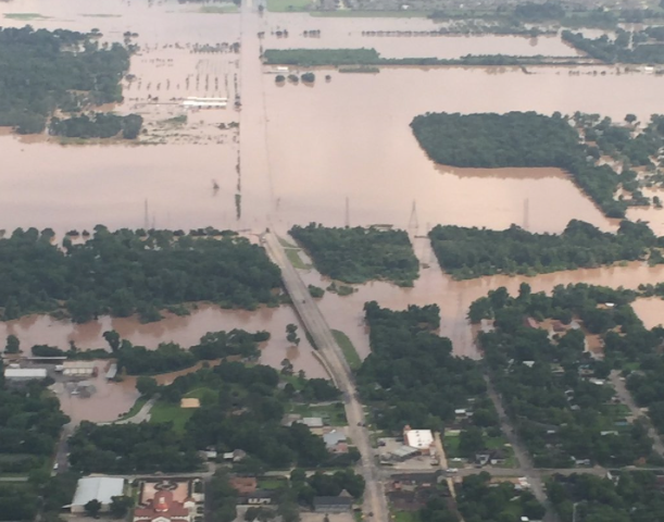
Brazos River in Fort Bend County has surged to its highest level in over a century. The river is located about 30 miles southwest of Houston. https://twitter.com/ABC/status/737877198846185472 After days of heavy rain, flooding continues to occur in the area outside of Houston which has killed six people and damaged many homes. The National Weather Service issued a […]

AUSTIN, Texas — Today, Monday, Jan. 25, is the last day Texans may register for disaster assistance from the Federal Emergency Management Agency (FEMA). Survivors of the Oct. 22-31 disaster can register today: By calling the toll-free FEMA Helpline (voice, 711 or relay service) at 800-621-3362, until 10 p.m. (CST). TTY users should call 800-462-7585., or By […]

Some huge casting has been announced for X-Men Apocalypse, and the news has tinged excitement for the film with a little caution. Director Bryan singer…

Marvel mastermind Stan Lee just let it slip that Marvel Studios is finally bringing a black hero center stage for their very own movie! Yes,…

(HOUSTON) — With the peak of hurricane season here, now is the time to review the basics of preparedness. By now, you should know that…
Super Typhoon Haiyan — being named the strongest storm ever — plowed Friday across the central Philippines, leaving widespread devastation in its wake. So far only 4 people have been reported dead, hundred of thousands have evacuated. Read the Full story here.
More than 2400 flights have been canceled due to the Nemo blizzard in the northeast, and that’s affecting flights here in Houston. More from News…
They are often the ones without a voice, left behind in a natural disaster. But 70 animals from Louisiana are now in Houston, in hopes of…

NHC Atlantic Outlook ZCZC MIATWOAT ALL TTAA00 KNHC DDHHMM TROPICAL WEATHER OUTLOOK NWS NATIONAL HURRICANE CENTER MIAMI FL 200 PM EDT THU AUG 23 2012 FOR THE NORTH ATLANTIC...CARIBBEAN SEA AND THE GULF OF MEXICO... THE NATIONAL HURRICANE CENTER IS ISSUING ADVISORIES ON TROPICAL STORM ISAAC...LOCATED ABOUT 165 MILES SOUTH OF SAN JUAN PUERTO RICO...AND RECENTLY UPGRADED TROPICAL STORM JOYCE...LOCATED ABOUT 1305 MILES EAST OF THE LEEWARD ISLANDS. 1. SHOWER AND THUNDERSTORM ACTIVITY REMAINS MINIMAL IN ASSOCIATION WITH A TROPICAL WAVE LOCATED BETWEEN THE WEST COAST OF AFRICA AND THE CAPE VERDE ISLANDS. ANY DEVELOPMENT OF THIS DISTURBANCE IS EXPECTED TO BE SLOW TO OCCUR...AND THIS SYSTEM HAS A LOW CHANCE... 10 PERCENT...OF BECOMING A TROPICAL CYCLONE DURING THE NEXT 48 HOURS AS IT MOVES GENERALLY WESTWARD AT ABOUT 15 MPH. ELSEWHERE...TROPICAL CYCLONE FORMATION IS NOT EXPECTED DURING THE NEXT 48 HOURS. $$ FORECASTER BROWN NNNN

NHC Atlantic Outlook ZCZC MIATWOAT ALL TTAA00 KNHC DDHHMM TROPICAL WEATHER OUTLOOK NWS NATIONAL HURRICANE CENTER MIAMI FL 200 PM EDT WED AUG 22 2012 FOR THE NORTH ATLANTIC...CARIBBEAN SEA AND THE GULF OF MEXICO... THE NATIONAL HURRICANE CENTER IS ISSUING ADVISORIES ON TROPICAL STORM ISAAC...LOCATED ABOUT 95 MILES EAST-SOUTHEAST OF GUADELOUPE IN THE LESSER ANTILLES...AND TROPICAL DEPRESSION TEN...LOCATED ABOUT 860 MILES WEST-SOUTHWEST OF THE CAPE VERDE ISLANDS. ELSEWHERE...TROPICAL CYCLONE FORMATION IS NOT EXPECTED DURING THE NEXT 48 HOURS. && PUBLIC ADVISORIES ON TROPICAL DEPRESSION TEN ARE ISSUED UNDER WMO HEADER WTNT35 KNHC AND UNDER AWIPS HEADER MIATCPAT5. FORECAST/ADVISORIES ON TROPICAL DEPRESSION TEN ARE ISSUED UNDER WMO HEADER WTNT25 KNHC AND UNDER AWIPS HEADER MIATCMAT5. $$ FORECASTER KIMBERLAIN/ZELINSKY NNNN
NHC Atlantic Outlook ZCZC MIATWOAT ALL TTAA00 KNHC DDHHMM TROPICAL WEATHER OUTLOOK NWS NATIONAL HURRICANE CENTER MIAMI FL 800 PM EDT SUN AUG 5 2012 FOR THE NORTH ATLANTIC...CARIBBEAN SEA AND THE GULF OF MEXICO... THE NATIONAL HURRICANE CENTER IS ISSUING ADVISORIES ON TROPICAL STORM ERNESTO...LOCATED ABOUT 245 MILES EAST OF CABO GRACIAS A DIOS HONDURAS...AND ON TROPICAL STORM FLORENCE...LOCATED OVER THE EASTERN ATLANTIC OCEAN ABOUT 770 MILES WEST OF THE CAPE VERDE ISLANDS. ELSEWHERE...TROPICAL CYCLONE FORMATION IS NOT EXPECTED DURING THE NEXT 48 HOURS. $$ FORECASTER KIMBERLAIN NNNN