
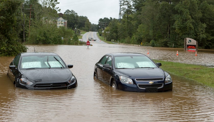
This is crazy! It’s sunny outside, not a raindrop in sight and yet, there’s a massive flooding event in Houston, particularly near the Houston Ship Channel. A water main break near 610 East Loop and Clinton has led to massive flooding, creating a standstill on roads and more. A few cars were stranded in the […]

The City of Houston Office of Emergency Management (OEM) urges residents and visitors to avoid Houston roadways during periods of prolonged or intense rainfall. The Department of Public Works & Engineering and OEM have produced a map of roadway segments and underpasses that are especially prone to flooding. Travelers should heed special caution around these […]

The following water/municipal utility districts have issued unsafe water notifications as follows: Inverness Forest Subdivision Residents P&B Water System UV6 Water System The SRC Water Supply/Lass Water Company System (Sellers Estates) To ensure destruction of all harmful bacteria and other microbes, water for drinking, cooking, and making ice should be boiled and cooled prior to […]
With donations to the Greater Houston Storm Relief Fund (GHSRF) approaching $1.8 million, Mayor Sylvester Turner announced the guidelines that will be followed in dispersing the funds to help victims of the April 18, 2016 Houston-area flooding. Only nonprofit organizations, public agencies and governmental bodies providing direct support for the immediate and short-term needs of […]
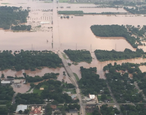
Brazos River in Fort Bend County has surged to its highest level in over a century. The river is located about 30 miles southwest of Houston. https://twitter.com/ABC/status/737877198846185472 After days of heavy rain, flooding continues to occur in the area outside of Houston which has killed six people and damaged many homes. The National Weather Service issued a […]
Attorneys from the Houston Bar Association will answer questions and provide legal advice over the phone for those in the Houston area affected by the recent floods and severe weather. From May 2-May 6, the public can call 713-759-1133 from 8:00 a.m. until 5:00 p.m. to speak to an attorney knowledgeable in insurance matters, property, […]
The National Weather Service (NWS) has issued a Flash Flood Watch for the City of Houston from Friday afternoon through Sunday Morning. This means that during this period, conditions will be such that any storms forming in our area during this period may cause flash flooding. NWS is forecasting 2-4 inches over our area, with […]
There’s a reason why insurance companies usually declare flooded vehicles a total loss. Once an engine gets waterlogged, it’s almost impossible to ever make it right. Unfortunately, some unscrupulous sellers will try to buy these cars at auction and resell them to unsuspecting buyers. Here’s what to do if that used car deal looks too […]
Texas Governor Greg Abbott’s office today confirmed that President Obama has approved the governor’s request for a federal disaster declaration for Fayette, Grimes, Harris and Parker counties. The action paves the way for federal recovery assistance to begin flowing into the Houston area. “I hope this leads to help for all of our residents who […]
Texas Governor Greg Abbott requested individual assistance for Harris, Fayette, Grimes and Parker counties from the federal government. If the request is granted by President Obama, affected citizens in Houston and the surrounding communities may be eligible for grants of up to $33,000 and low-interest disaster loans from the U.S. Small Business Administration. The latest […]

NOAA-NASA GOES Project(NEW ORLEANS) -- Hurricane Isaac pounded the Gulf Coast Wednesday, overtopping a levee southeast of New Orleans, knocking down trees and cutting power to more than 400,000 homes. There were no reports of injuries but dozens of residents of Plaquemines Parish, La., were stranded atop a levee, while there were multiple reports of people trapped in attics by rising waters. Thus far, fewer people were evacuated than during Hurricane Katrina, which hit New Orleans seven years ago today. But the Category 1 slow-moving storm is expected to stay over the region all day with its drenching rains and high winds. As of 9 a.m. the storm's center was about 40 miles southwest of New Orleans, according to the National Hurricane Center. At 9 a.m., 30 to 40 vehicles were stranded atop the levee in Plaquemines waiting for a ferry, with water all around, according to a contractor who works for the parish. That ferry is the only way off that flooded spit of land. A source told ABC News that nearly the entirety of the area has been flooded, and winds still howling at 35-40 mph, prevented a ferry from approaching. It is estimated that it will be six to eight hours before it's safe for the ferry to motor out to the stranded people, who were without power but do have cell phone service. Thousands who live in the area are still stuck in their homes or attics, and rescuers are out in boats helping those who need it most. "I've got a four-by-four hole in my roof, several pieces in the front yard, the back wall of my house moved a couple of feet, and with each gust of wind, it's like you're breathing in and out," William Harold "Billy" Nungesser, president of Plaquemines Parish, told Good Morning America.Nungesser confirmed that a levee in Plaquemines Parish was overtopped with water, causing flooding. So far there were no reports that the $14 billion of levees and pumps put up around New Orleans after Katrina have been breached, but officials have not yet fully assessed the situation. "The water came up so quickly and overtopped the levees from Breakaway to White Ditch on the east back of the north end of the parish. It's an area that we called for a mandatory evacuation," he said. At daylight, parish officials were out examining the damage, according to James Madere, a parish geographic information system analyst. The Plaquemines Parish Public Information Office tells ABC News that rescue operations will not start until it is safe, possibly as late as 1 p.m. ET. In New Orleans, power lines were down, snaking and sparking across city streets after transformers exploded across the city Tuesday night. The city saw handfuls of arrests early as looters took advantage of the chaos, sheriffs and police and National Guard were all out in force. The hurricane promised to lend even more solemnity to commemoration ceremonies Wednesday for Katrina's 1,800 dead in Louisiana and Mississippi, including the tolling of the bells at St. Louis Cathedral overlooking New Orleans' Jackson Square. This storm is far less powerful at Category 1 than Katrina, which caused at least $81 billion in damage and was rated as the most powerful Category 5 storm. As of 9 a.m., Isaac was still packing winds of 80 mph. Isaac is moving at near 6 mph and has already dropped more than six inches of rain on New Orleans. Hurricane force winds extend 60 miles from the center of the storm. The hurricane had moved back into the Gulf of Mexico after making its initial landfall Tuesday evening. Isaac's center remained over water where it was almost stationary before making landfall again this morning. The 200-mile wide hurricane is expected to gradually weaken and move inland in a northwestward motion, dumping seven to 14 inches of rain across Louisiana, with some places receiving up to 20 inches, according to forecasters. The greatest concern is an expected storm surge of between six and 12 feet off the Louisiana and Mississippi coasts, four to eight feet along the Alabama coast and three to six feet on the Florida Panhandle, according to the Hurricane Center located in Miami. A storm surge of 11 feet was reported at Shell Beach, La., late Tuesday while a surge of 6.7 feet was reported in Waveland, Miss., according to the Hurricane Center. The highest wind gust was recorded at 113 miles an hour overnight in Belle Chasse, Plaquemines Parish, La. Thursday night into Saturday, Isaac will move into the Mississippi Valley and eventually into Illinois and Indiana with possibly six inches of rain for the drought-stricken Midwest. Isolated tornadoes are possible along the central Gulf Coast region and part of the lower Mississippi River Valley through Wednesday, according to the National Oceanic and Atmospheric Administration. Entergy New Orleans has listed more than 400,000 homes and businesses without power as of 5:30 a.m., according to their website. The Red Cross reported 18,000 people in 70 shelters across five states Wednesday morning. video platformvideo managementvideo solutionsvideo player Copyright 2012 ABC News Radio

News92FM.Com is saying that you should prepare for some usage of those umbrellas and rain gear because this week will be the week you will need it. According to Houston area forecasters a windy and humid Monday will give way to some stormy weather on tap Tuesday. Read More [ione_media_gallery legacy_id=”305597″ src=”https://newsone.com”%5D